Walk to the Sea

Rose Kennedy Greenway

The Rose Kennedy Greenway, completed in 2008, is a network of gardens and public spaces that sits atop a massive underground highway project.

Maginfy icon
Maginfy icon Black and white photograph of ongoing elevated highway construction in front of Customs House Tower
Maginfy icon Photograph from around 1947 depicting the construction of the central artery
Maginfy icon 1972 photograph depicting traffic on the central artery next to haymarket square

Here stood Boston’s “Highway in the Sky,” so labeled in the 1950s by local media expressing the official hopes for a new elevated expressway.

Boston’s leaders chose to raze hundreds of homes and commercial buildings for the progressive project. The expressway was to decongest Boston’s obsolete and crooked street network and “prune” away decayed portions of the city, inviting new investment downtown.

However, the highway and its supporting structure effectively cut off Boston’s North End and waterfront from the rest of the city, and it came to be regarded as an eyesore. When traffic overwhelmed the expressway, Boston sought federal assistance to enlarge and bury the Central Artery, a project known as “The Big Dig.”

The Rose Kennedy Greenway, completed in 2008, is a network of gardens and public spaces, named for the mother of long-serving, distinguished Massachusetts Senator Edward M. Kennedy and his brothers, President John F. Kennedy and New York Senator Robert F. Kennedy.

The mile-and-a-half Greenway extends from the Leonard P. Zakim Bunker Hill Bridge, past the North End and Wharf District, to Chinatown Gate. The Greenway serenely caps the massive traffic flow along the expressway buried beneath it.

The “Big Dig,” a reconstruction of three-and-a-half miles of expressway, completed in 2007, became known as America’s most expensive public works project. Today, traffic is routed underground, and now parks reconnect downtown Boston to the city’s historic North End, wharves, and waterfront.

Resources

  • More or Less in Common: Environment and Justice in the Human Landscape

    What kinds of images come to mind when you think about the environment? Trees, water, green landscapes, and scenic vistas? But what about people—communities, housing, roads, neighborhoods, cities, schools, and factories? These are all a part of the environment too. And environmental issues can’t be set apart in a distinct category from social questions. Humans and the natural world are deeply connected, through the past, present, and future.

    Visit
  • Rose Fitzgerald Kennedy Greenway Conservancy

    The Conservancy has sole responsibility for managing all aspects of the Rose Kennedy Greenway, including horticulture, programming, public art, maintenance, and capital improvements.

    Visit

Essays

    The West End vs The Highway

    by Scarlett Held
    This essay was written as a student project for HIST 7250: Practicum on the Place-Based Museum at Northeastern University in Fall 2024.

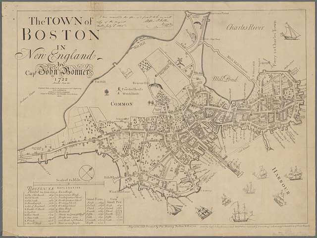
    map of historic west end

    Historic map of Boston and Mill Pond

    Neighborhoods of The Past

    The West End

    Aerial view of the West End

    The West End

    Similar to most of Boston, the West End was once a marsh. The marsh was then dammed and developed to account for population growth. The West End has been an important neighborhood in Boston since the Revolutionary War, especially for African Americans, a large community of Irish, and other working class immigrants. Separated from the North End by Mill Pond, the West End was originally farmland, and then it became home to the transportation hub for the area. Workers from Beacon Hill and the waterfront moved to the West End after it was filled in with land. With the increase of immigrant populations to the area came the rise of tenement buildings and the poor living conditions within. Although it was home to such a diverse population of people, the West End did not have the luxury of Beacon Hill nor the waterfront access of the North End. When it came time to destroy neighborhoods, it is no surprise the West End was first to go. Despite the rich cultural history of the West End, there is little community left within the neighborhood today. So why is that legacy largely missing from the modern streets of the West End today?

    The West End Renewal Project

    Signage posted during redevelopment

    Age of Highways

    The 1950s saw extreme growth to the highway system, and cities around the country had to figure out how to make space for the new roads. Boston had a clear plan, tearing down historic working class neighborhoods. Among those lost were the West End, Downtown, and Chinatown. All of these neighborhoods were home to diverse working class communities. The Boston Housing Authority built its plan for urban redevelopment around tearing down the ‘slum’ that was the West End. Over 20,000 people were evicted from their homes to create the I-93’s “central artery”. They were given $1 and told they would get the rest of the value at a later date. When that day came all they got was at a fraction of the worth of the homes. Some of Boston’s oldest public squares Adams Square, Scollay Square, and Haymarket Square were completely destroyed to promote commuting between predominantly white suburbs and the city. The highway did not only destroy neighborhoods, it cut off the North End, an Italian neighborhood, from the rest of the city. The central artery segregated the neighborhood from the rest of the city by way of an elevated multilane highway. The communities lost during the era of development could never come back. Even as homes were rebuilt, families had been gone for generations. For those in power the 1950s were a period of ‘hatred’ towards the city of Boston. With the wealthy white populations moving into suburbs the focus of development was commuting. The old streets of Boston were seen as dirty and old, detrimental to the makeup of the suburbs. Fred Salvucci, who came up with the idea for the ‘Big Dig’, had this to say about this era in urban planning “…In the ’50s, we just knocked those buildings down. That’s a pretty vandalistic way to deal with what I think is a really great city.” Among the historic buildings razed, was the office where The Liberator was published, the paper that served as the heart of the abolition movement in the United States.

    Making room for the road

    Destruction to make way for the highway

    The Big Dig

    Fred Salvucci’s grandmother lost her home when they built the Mass Pike, his brother in law was evicted from his home in the West End to make room for the central artery. When Salvucci grew up he would mastermind the burial of the elevated highway that later became known as the Big Dig. His goal going into urban planning was to build roads and tunnels that did not hurt people or destroy communities. The Big Dig changed a lot for the city of Boston, allowing the North End to rejoin the rest of the city and getting rid of a traffic-filled polluter, but it could not undo the damage previously done. Ian Cross interviewed Chinatown native Randy Tow about the rebuilding of previously destroyed neighborhoods, for his “The Big Dig” podcast with GBH News, “It was a good gesture. It was something better than not having anything you can never really replace a neighborhood. Nor is anybody asking you to do it. It’s impossible.” The 1950s were an extremely damaging time, a legacy Boston will be faced with forever. The Boston Redevelopment Authority apologized in 2015 for razing the West End. The city has tried to make amends for its actions, but some things are not so easily fixed.

    protests to protect chinatown

    Chinatown residents protesting highway ramp expansion

    The Greenway and Today

    With the highway now underground, what used to be the elevated highway is now a park. The city is now reconnected to the North End and its own waterfront. The 17 acre and 1.5 mile long park stretches between those lost neighborhoods. It can never replace the communities displaced in the 50s but it is a lot better than a highway. The Rose Kennedy Greenway is home to community events nearly every night of the week. From beer gardens, artisan markets, food festivals, and exercise classes the park is once again a place for people to come together. The West End is now home to TD Garden and Mass General Hospital. It is no longer rows of brick houses but instead high rise buildings, most of which are nonresidential. North Station, the hub of transportation in the city, is only a ten minute walk away from the Greenway. The West End Museum and the Last Tenement, another ten minute walk, are open to ensure the long history of the neighborhood is remembered.

    Sources

Map icon Open map
Walk to the Sea logo Normal V. Leventhal Map & Education Center logo

Designed by Ummo